


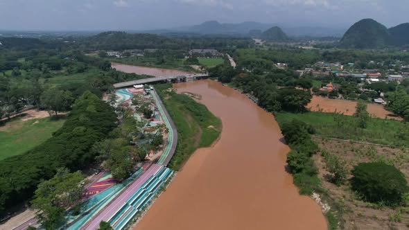
The Kok River enters Thailand at Tha Ton in Chiang Mai Province, then flows through Chiang Rai Province to the Mekong. Today, it remains part of daily life in Chiang Rai, where communities rely on the river and its surrounding land.
Its route is clear, but some claims about the Kok’s role in ancient Lanna history are harder to establish. A careful account separates what the historical record supports from what remains uncertain, while recognizing the river’s place in the region today.
Start with the Kok’s course through northern Thailand, then consider what the evidence can tell us about its past.
Key Takeaways
- The Kok enters Thailand at Tha Ton in Chiang Mai Province, crosses Chiang Rai, and joins the Mekong, as described in this account of the river’s route.
- Available records establish the river’s course, but don’t confirm claims that it shaped Chiang Rai’s founding or Lanna-era trade.
- The reviewed evidence doesn’t provide reliable dates for historic bridges, crossings, or specific settlements along the Kok.
- Heavy-metal concerns reported since 2025 have focused attention on upstream mining and water monitoring.
- Keep suspected pollution distinct from documented history, and raw river readings separate from treated-water results; Mekong River Commission monitoring efforts add regional context.
The History of the Kok River in Chiang Rai, from its route to its past
The Kok’s course provides a clear geographic starting point for its history. It enters Thailand at Tha Ton in Chiang Mai Province, continues into Chiang Rai Province, and eventually joins the Mekong. The river crosses boundaries that matter to local communities and regional water management, but its route alone cannot confirm the part it played in earlier events.
How the Kok connects Chiang Mai, Chiang Rai, and the Mekong
From Tha Ton, the Kok flows southeast through northern Thailand before crossing into Chiang Rai Province. It passes through the province and empties into the Mekong, a much larger river that forms part of the border between Thailand and Laos. The Kok therefore links communities in two Thai provinces with the broader Mekong basin.
That connection has practical consequences. Water moves downstream regardless of provincial or national boundaries, so conditions upstream can affect people and ecosystems farther along the river. Decisions about monitoring, pollution, and water use may involve communities and authorities on both sides of the border, as well as the wider Mekong system. The Stimson Center’s overview of the Kok and other Mekong tributaries discusses this cross-border setting.
The river’s route is also a useful way to understand Chiang Rai’s place in the region. The province is not the Kok’s only point of reference: the river reaches it after passing through Chiang Mai, then carries water onward to the Mekong. For a closer look at its course through the province, see this account of the Kok River’s route from Tha Ton.
Geography, however, does not prove that a particular historical event happened along the river. A waterway can connect places without showing when people traveled along it, what they carried, or which rulers controlled its banks. Those questions require historical sources tied to specific dates and places.
What the record can and cannot confirm about the river’s early history
The available evidence confirms the Kok’s broad route, but it does not establish a specific role for the river in Chiang Rai’s founding. It also does not verify that the Kok formed a major Lanna-era trade route or document named rulers’ activities along its banks. Those claims may seem plausible because the river links settlements and regions, but plausibility is not proof.
A sound account should keep documented geography separate from unresolved history. The known course tells us where the river flows today. On its own, it cannot identify an ancient landing place, establish a trade network, or connect the Kok to a named ruler. Nor can it supply a reliable date for a crossing, bridge, or settlement without a source that records that detail.
The gaps matter because general descriptions of northern Thailand’s history can tempt writers to attach broad regional events to a specific river. A reference to Lanna trade, for example, does not show that goods traveled on the Kok. Similarly, a known founding account for Chiang Rai would not establish that the river determined the city’s location or played a documented role in its establishment.
Stronger evidence could come from local archives, dated maps, inscriptions, and carefully sourced oral histories. Each source would need close examination: a map must be dated and interpreted in context, while an oral account should identify its narrator and how the story was passed down. Inscriptions may record people or places, but researchers would still need to establish whether they refer to the Kok or its surrounding area.
Until such evidence is identified, the most accurate account is measured. The Kok connects Chiang Mai and Chiang Rai with the Mekong, yet the available record does not settle how it figured in Chiang Rai’s early history or Lanna-era trade. Keeping that distinction clear gives the river’s documented geography its due without turning unanswered questions into established facts.
Why the Kok River mattered to communities and movement
The Kok River’s practical importance is easier to describe than its exact place in early history. Rivers can supply water, food, and routes between settlements, but those general patterns don’t prove how people used a particular stretch of the Kok in a named period. For that, dated local records and reliable studies matter.
Water, farming, and life along the river
Waterways support farming by providing water for crops, livestock, and household tasks. In the Kok basin, irrigation systems draw on rivers and tributaries, as documented in a JICA report on community irrigation. This helps explain why water access would matter to riverside communities, though it doesn’t establish when a particular system began or how people farmed along a specific stretch in the past.
The river can also support fishing and other daily needs. Current accounts describe farming and fishing as part of life in communities such as Ban Ruam Mit, alongside household use of river water. The UNDP account of Kok River communities offers a present-day view, not evidence that every community used the river in the same way across earlier centuries.
A riverbank can attract settlement because water and cultivable land are close at hand. Yet that broad pattern should not be turned into a specific claim about the Kok without evidence. The available record discussed here does not establish which historic settlements depended on river water, when irrigation began, or whether a named group relied on particular fish or crops.
Modern reporting makes the economic connection visible. A report on farming and fishing along the Kok describes river-fed irrigation and livelihoods in the basin. Those details help readers understand the river’s present-day role; they should not be projected backward as proof of historical practices. For a claim about an earlier community, look for dated local records, maps, archaeological evidence, or carefully documented oral histories.
River crossings and links between settlements
Boats, fords, ferries, and bridges can shape movement along a river. A boat may carry people or goods where banks are accessible; a ford can offer passage when water levels allow; a ferry or bridge can connect routes that would otherwise stop at the water’s edge. These are general ways waterways affect travel, not confirmed descriptions of particular Kok River crossings.
Crossings can also influence which settlements interact regularly. When people can move across a river, they may reach markets, farms, relatives, or services more easily. However, the existence of a river does not tell us which crossing people used, how often they traveled, or whether trade passed through a particular location. Those details require sources tied to a place and date.
For the Kok, the available evidence does not establish the names, dates, or historical importance of specific bridges, ferries, or fords. Modern crossings or travel routes cannot fill that gap on their own. A careful account should describe their possible function in general terms, then identify the local evidence needed to confirm a particular route or event.
The river’s role in movement is therefore a question for further research, not a settled historical claim. Dated maps, administrative records, travel accounts, and archaeological findings could show where people crossed and how those routes connected settlements. Until such evidence is available, the strongest account recognizes that rivers can link communities while avoiding unsupported claims about exactly how the Kok did so.
How the Kok became a modern waterway under new pressures
The Kok still supports farming and tourism in Chiang Rai, but its present-day story now includes concerns about water quality and upstream activity across the Myanmar border. Reports since 2024 document unusual changes in the river’s appearance, followed by monitoring for arsenic and other metals.
The pollution concerns reported since 2024
Communities reported unusually turbid water in April 2024. After severe flooding in September, the river remained muddy into March 2025, when conditions would usually be clearer during the dry season. The change raised concerns because turbidity can come from sediment as well as pollution, and appearance alone cannot identify what is in the water.
Thailand’s Pollution Control Department began monitoring the Kok in March 2025, after reports of abnormal turbidity and arsenic in rivers flowing from Myanmar’s Shan State. The Bangkok Post reported the start of local sampling. Subsequent 2025 testing found arsenic and other metals, including lead, mercury, and manganese, above national standards at some sampling locations.
Those results varied by place and sampling round. For example, a report on PCD testing in June 2025 found elevated arsenic at several sites, including locations near the Myanmar border and in Chiang Rai. The June 2025 Kok River test results show why it matters to track specific sampling dates and stations rather than describe the entire river as uniformly contaminated.
A result above a standard in a raw river sample does not mean every sample exceeded the limit or that all river water was unsafe. Nor does a reading from one period describe conditions throughout the year. Heavy rain, changing river flow, and sediment disturbance can affect measurements, so monitoring over time is essential.
Why cross-border mining and water monitoring matter
Reports have linked suspected mining upstream in Myanmar to contamination concerns in the Kok and other northern Thai rivers. Satellite imagery and environmental sampling have raised questions about rare-earth and gold mining, but available evidence does not establish responsibility for every contaminant at every site. The Stimson Center’s reporting on upstream mining describes the reported activity and the cross-border nature of the concern.
That distinction matters because the Kok flows across national boundaries. A source upstream can affect downstream water, yet determining where a contaminant came from requires evidence that connects mining activity, water or sediment samples, and specific locations. Community concerns and calls for action help draw attention to the issue, but they are not scientific proof of a pollution source.
Water quality also affects more than drinking supplies. Farmers use river water for irrigation, while tourism and other local livelihoods depend on the river and its surroundings. The USDA Foreign Agricultural Service reported concern about irrigation in the region, alongside testing that found sampled food and tap water within safety standards. Those findings address different questions: tests of raw river water do not automatically describe treated tap water.
In July 2026, the Chiang Rai Provincial Waterworks Authority reported that tap water met standards at its five production stations. That does not erase findings from raw-water samples; treatment separates the water people receive from the river water collected before processing. Keeping those results distinct helps residents understand both the risks under monitoring and the protections reported by water providers.
Communities have also called for stronger monitoring and action on suspected upstream mining. Their concerns reflect the river’s importance to agriculture, tourism, and daily life. Reliable cross-border data and continued testing are needed to clarify changing conditions and support decisions about river use.
What remains to be documented in the Kok River’s history
The Kok’s route and present-day importance are clear, but many details of its earlier history remain unverified. A stronger account depends on dated, traceable evidence, with each source used for what it can actually establish. That approach can preserve local knowledge while avoiding claims that turn plausible stories into confirmed events.
How to separate local memory from confirmed dates
Interviews with elders can preserve names, place references, and accounts of how people used the river. Those memories may point researchers toward old crossings, floods, or changes in settlement. However, an account collected today cannot establish a precise date by itself. Present it as a person’s recollection unless independent evidence confirms the event and its timing.
For each interview, record who shared the account, when and where it was collected, and how the narrator learned the story. With permission, preserve the recording or a transcript, and note any limits on access or publication. The Oral History Association’s best practices for documenting interviews offer guidance on preserving context and respecting narrators.
Then compare the account with sources that can add dates or corroboration. A dated map may show a settlement, road, or river channel at a particular time, but it cannot prove how residents used a crossing. Government files and temple records may contain names, land references, or local events; researchers still need to check when each record was created and what it was meant to document. Archaeological findings can provide evidence of past activity, though they require careful dating and a clear connection to the Kok’s banks.
Local newspapers can help identify events and direct researchers to people or records. They should be treated as one part of the evidence, not automatic confirmation. When sources disagree, a careful account should describe the difference rather than choose the most vivid version.
Why the river’s future is part of its history
Historical records continue to take shape as people document the river now. Water-monitoring results, dated community observations, and official reports can establish how conditions change over time. Each record should identify the sampling location, date, method, and what was measured. A water-level reading, for example, documents river height, not the presence or absence of contaminants.
The Mekong River Commission’s data portal provides regional time-series and water-quality data. Such information can offer useful basin context, but it should not be presented as a Kok-specific finding unless the relevant dataset covers the river and its sampling sites. Likewise, community water-level monitoring along the Kok records local observation and preparedness, distinct from laboratory water-quality testing.
Cross-border cooperation matters because the Kok flows from Myanmar into Thailand and onward toward the Mekong. Shared monitoring can make records easier to compare across locations and time periods. Community concerns also belong in the record: interviews, meeting notes, and local reporting can show how environmental changes affect daily life. Those sources document experience and response; they do not, by themselves, identify the source of a pollutant.
Taken together, maps, archives, archaeology, interviews, reporting, and monitoring data can build a more reliable history. The Kok’s story is both a history of place and an ongoing record of environmental change. As new evidence appears, each claim should remain tied to its source, date, and limits.
Frequently Asked Questions
The Kok’s route is well established, while some claims about its earlier history remain unconfirmed. These answers separate documented facts from questions that still need stronger local records.
Where does the Kok River flow through Thailand?
The Kok enters Thailand at Tha Ton in Chiang Mai Province, then flows through Chiang Rai Province before joining the Mekong. This route connects two northern Thai provinces with the Mekong basin, but it does not by itself document how people used the river in the past.
Is the Kok River known to have shaped Chiang Rai’s founding?
The river is central to the geography of Chiang Rai, but the available sources don’t confirm that it directly shaped the city’s founding. Without a reliable historical source linking the river to the city’s establishment, a specific founding story would go beyond what the record supports.
Did the Kok River serve as a historic trade route?
River travel and trade are reasonable subjects for research, but the available evidence doesn’t confirm a specific Kok River trade route or the dates when it may have operated. A firm claim would need dated local records, such as maps, administrative documents, or travel accounts that identify the river and the activity. General evidence of trade in northern Thailand does not establish that goods moved along the Kok.
When did reports of water pollution begin?
Reports of unusual turbidity date to April 2024, and muddy conditions continued after the September 2024 floods. Thailand’s Pollution Control Department began official monitoring in March 2025. These dates describe reported changes and the start of monitoring; they don’t identify a pollution source on their own.
Do river test results mean tap water is unsafe?
No. Raw river samples are collected before treatment, while tap water has gone through a separate process and must be assessed on its own test results. Some reports found contaminants above standards at river monitoring points, while separate reporting said treated water at monitored facilities met standards. The USDA’s report on northern Thailand’s water and agriculture distinguishes concerns about river water from findings on tested tap water; see also the Chiang Rai water authority’s reported Kok River assessment.
Conclusion
The Kok is a cross-border waterway that connects Chiang Rai’s landscape with communities upstream and the Mekong downstream. Its place in daily life is clear, even as important details of its documented past remain unresolved.
That distinction matters: the river’s known course and present-day pressures should not be confused with historical claims the record does not support. Careful research and clear water monitoring can help communities protect the Kok and build a reliable record of its next chapter, including how Chiang Rai tracks water conditions along the river.