


CHIANG MAI – Provincial officials in northern Thailand are rolling out high-tech surveillance cameras and a dedicated mobile reporting app ahead of the 2027 dry season to stop illegal forest fires before thick smoke chokes the region.
Under the Chiang Mai Sandbox clean-air blueprint, authorities aim to cut fire hotspots by 25%, shrink burned forest areas, reduce days with unhealthy PM2.5 levels by 20% to 59 days, and lower chronic obstructive pulmonary disease cases by 20% to a target of 12,870 patients. The early push shifts provincial strategy from late-stage firefighting to rapid detection and ground-level prevention.
Key Takeaways
- Surveillance Tech: High-risk forest zones will receive remote monitoring cameras paired with the “Phai Phao Rao Han” app to pinpoint illegal fires in real time.
- 2027 Targets: Officials want a 25% drop in fire hotspots and a 20% reduction in both hazardous PM2.5 days and COPD hospital cases.
- Community & Water Plans: Local volunteer fire crews will verify alerts on the ground while agencies stockpile water reserves to prevent dry-season shortages.
Cameras and App Target Early Blaze Detection
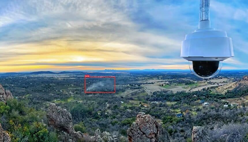
Speed decides whether a brush fire becomes an ecological crisis. Provincial disaster planners are installing remote cameras across rugged, high-risk forest ridges to scan for smoke plumes around the clock. Those feeds connect directly to the “Phai Phao Rao Han” (“You Burn, We See”) mobile application, allowing residents and forest rangers to log exact coordinates of unauthorized burns.
Once an alert hits the command center, dispatchers cross-check camera visuals against satellite thermal data from Thailand’s Pollution Control Department. Local village heads and volunteer fire teams then deploy on motorbikes and foot patrols to extinguish flames before wind drives them up steep mountain slopes.
Why the Chiang Mai Basin Traps Toxic Smoke
Chiang Mai’s geography turns seasonal agricultural and forest fires into a recurring public health emergency. Steep mountain ranges surround the city in a bowl-like valley. During dry winter and spring months, cool stagnant air settles over the basin, acting like a lid that prevents smoke from dispersing.
In April 2026, orbital imagery from NASA Earth Observatory captured dense plumes blanketing northern Thailand, pushing fine particulate readings deep into hazardous territory and driving up respiratory clinic visits. Past enforcement often stalled because fires ignited in remote watersheds at night, leaving crews blind until dawn. By pairing ground cameras with citizen reporting, officials hope to close that overnight blind spot and curb hospital admissions tied to PM2.5.
Volunteer Crews and Dry-Season Water Reserves
Technology alone cannot douse a forest fire without trained boots on the ridge. Provincial authorities are equipping community fire brigades with protective gear, portable leaf blowers, and direct radio links to district war rooms. Residents in buffer villages are also enlisted to maintain firebreaks and manage crop residue without matches.
Water scarcity poses an equal threat when firefighting peaks between February and April. Provincial irrigation and disaster agencies are mapping high-elevation check dams, filling mobile water tankers, and pre-positioning storage bladders near vulnerable forest perimeters. Those reserves ensure crews have immediate water access on steep terrain while protecting rural farm supplies during peak drought.