
(CTN NEWS) – On Thursday, NASA & NOAA will launch a new Earth observation satellite into space to help forecast the weather and detect increasingly common extreme weather events.
NASA’s Joint Polar Satellite System-2 (JPSS-2) is part of a global observation system developed through a partnership with NOAA.
As climate change continues to lead to more extreme weather events.
NOAA’s weather satellites have never been more critical, said Irene Parker, deputy assistant administrator for systems at NOAA’s National Environmental Satellite, Data, and Services.
The US experienced 104 separate billion-dollar disasters from 2017 to September 2022. In comparison, there were only 15 from 1987 to 1991.”
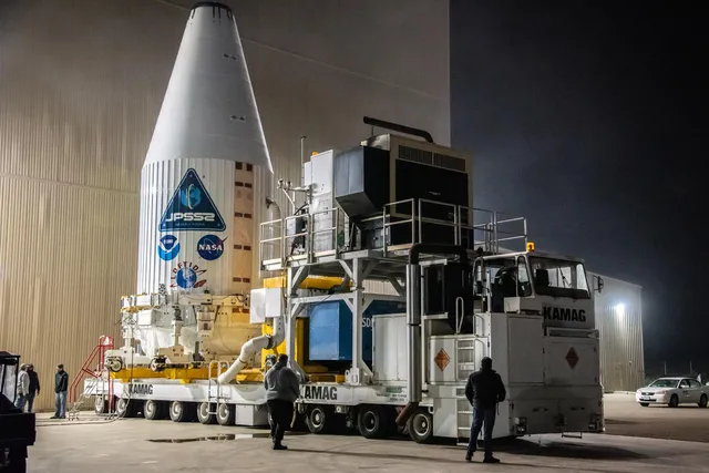
A United Launch Alliance Atlas V 401 rocket will launch JPSS-2 from Vandenberg Space Force Base in California at 4:25AM ET on November 10th.
A heat shield called LOFTID will also be tested on board, which could help land heavier payloads on Earth or Mars.
NASA and NOAA have a network of satellites observing the Earth’s environment, including JPSS-2’s predecessors, Suomi NPP and NOAA-20.
The JPSS-2 will join these two satellites in a polar orbit, circling the globe twice daily and covering the entire planet.
“We need to observe weather from a global perspective to predict local weather,” Tim Walsh, director of NOAA’s JPSS Program Office, said.
“A dust storm in Africa might affect the development of a possible hurricane. We might experience heavy rainfall here in California several days after a typhoon in Japan.”
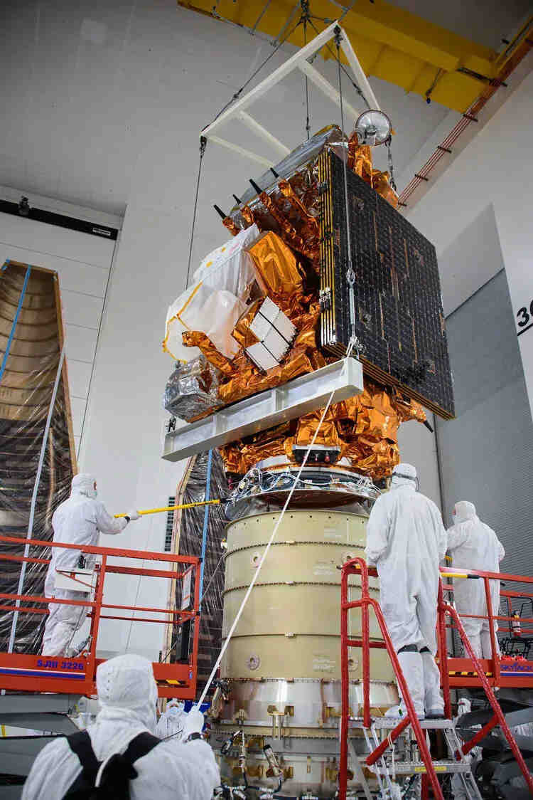
In addition to its four instruments, the JPSS-2 satellite’s Visible Infrared Imaging Radiometer Suite is its “eye.”
Researchers can use it to visualize features like domes of clouds known as overshooting tops, which indicate the severity of a thunderstorm, by taking visible and infrared images with a spatial resolution of about a quarter of a mile.
Ozone Mapping and Profiler Suite, or OMPS, examines ozone, while Cross-track Infrared Sounder, or Cris, builds a 3-D map of the atmosphere.
ATMs, or Advanced Technology Microwave Sounder, uses microwaves to identify storm strengths through clouds.
This combination of instruments will help weather forecasters monitor the Atlantic and Pacific oceans. Many weather stations gather data on land.
Few weather buoys can only take ocean measurements, so satellite data must be used to supplement these measurements.
In the past, JPSS data was used to predict the landfall of Hurricane Ian on the Florida coast, and it is currently being used to monitor Tropical Storm Nicole.
In a science briefing, Jordan Gerth, meteorologist and satellite scientist at NOAA’s National Weather Service, said, “JPSS data are a major input into global numerical weather prediction systems.”
“Observations are global; predictions are local.. JPSS forecasts are excellent for three- to seven-day forecasts.”
“Although the satellite is designed to predict the weather, that isn’t the only reason for its launch.”
Geostationary Operational Environmental Satellites, or GOES, are other NOAA satellite monitoring Earth for weather prediction.
GOES satellites, however, orbit 22,300 miles above Earth’s surface in a geostationary orbit, very different from JPSS satellites.
GOES satellites are always pointed at the same point on the globe, in contrast to JPSS satellites, which circle the globe and sit closer at just 500 miles away.
“JPSS is closer to the Earth’s surface so that we can obtain different types of observations,” Gerth explained.
Using instruments on the JPSS series, for example, we can determine the temperature structure of the atmosphere or the amount of water vapour.
As a result of JPSS, we can obtain information about the details under the cloud canopy, which can be translated into information about storm intensity and be used to predict storms.”
JPSS-2 data will also be useful for studying other climate conditions in addition to its weather forecasting duties.
Satya Kalluri, the program scientist at the NOAA JPSS Program, explained that the satellite is not only designed for weather prediction.
The satellite takes images of the Earth twice daily, enabling us to forecast food production based on drought conditions.”
Satellite data can also be used to measure the colour of the ocean, which can help identify harmful algal blooms and monitor ocean ecosystem health.
In addition to measuring air quality, it can observe changes to the polar ice caps and the hole in the ozone layer and identify smog or smoke from wildfires.
As well as JPSS-2’s ability to predict weather events in the short term, having consistent measurements of these factors over decades is critical to understanding the long-term impact of climate change.
“We are excited to see this launch of JPSS-2 because of its global collection of observations,” Gerth said. For meteorologists to make good local weather predictions, we need those global observations.
RELATED CTNNEWS:
NASA’s Moon Rocket Launch Has Been Delayed Again Due To Tropical Weather
6 Mac Keyboard Shortcuts You Should Always Use
Meta Layoffs 11,000 Employees: Read Mark Zuckerberg’s letter


