
(CTN News) A severe weather watch for tornadoes was issued Tuesday night. Avoid the roads if possible. When a tornado warning appears in your neighborhood, make a plan.
An official tornado watch indicates that severe storms, capable of producing tornadoes, are likely to develop. Should a warning be issued in your area, be prepared to seek shelter.
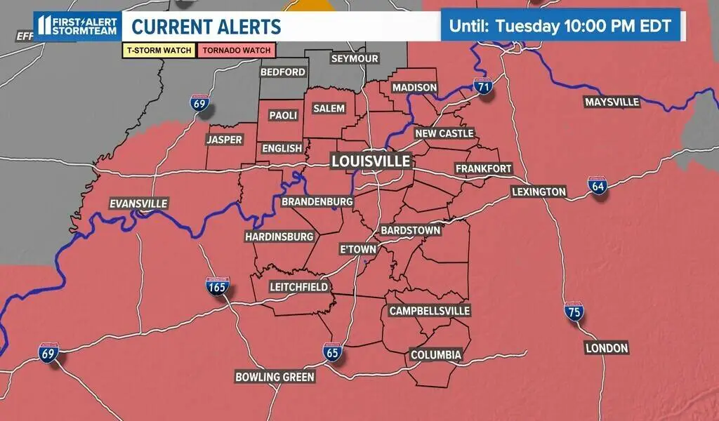
There is a risk of severe weather
Throughout the greater Louisville area, severe weather is expected this afternoon. On the Storm Prediction Center’s severe weather potential scale, this is level 4. This is the highest level of risk Kentuckiana has faced in six years. It is important to take the risk seriously.
WHAS11 meteorologists will provide live coverage of tornado warnings for any county within the viewing area on WHAS11.com, WHAS11+ and WHAS11 YouTube.
The timing
Until 8 p.m. Tuesday, but tornadoes can happen anywhere. The most likely time for tornadoes to form is when supercell storms form individually. Storms are expected to form rapidly today and cause a variety of severe weather conditions.
Any storm that develops could generate large hail, damaging winds, and frequent lightning in addition to tornadoes. There will be a lot of tornadoes and storms today. If you receive a severe thunderstorm warning or tornado warning in your area, act immediately.
For today’s power outage, make sure all appliances and smart phones are charged, that you have plenty of blankets, food and bottled water in case of power outage.
The CAPE variable is used by meteorologists to calculate storm energy. The following CAPE values are projected to impact central Kentucky and southern Indiana this afternoon:
Tips for dealing with severe weather
If Mother Nature produces a destructive, sometimes life-threatening thunderstorm, it is a good idea to familiarize yourself with severe weather safety tips.
Cold, windy air behind the system
In addition, model predictions point to a cooler than usual pattern throughout the latter part of the week. From Wednesday to Friday, temperatures are likely to range from the mid-50s to the lower 50s.
Numerous locations will see overnight temperatures close to freezing, if not slightly below freezing. Plants in bloom may be damaged by this.
As the storm marches east, we are also expecting strong winds. As a result of the strong cold front, wind gusts will howl between 25 and 35 mph in some rural areas, if not more.
If you drive a high-profile vehicle or own outdoor furniture that may easily blow around in the wind, please take note of this. On Thursday night, the wind will begin to taper off.
SEE ALSO:
Israel Bombs Iranian Embassy in Syria Killing Top Commander


