



Last Updated on September 23, 2026 by Jeff Tomas
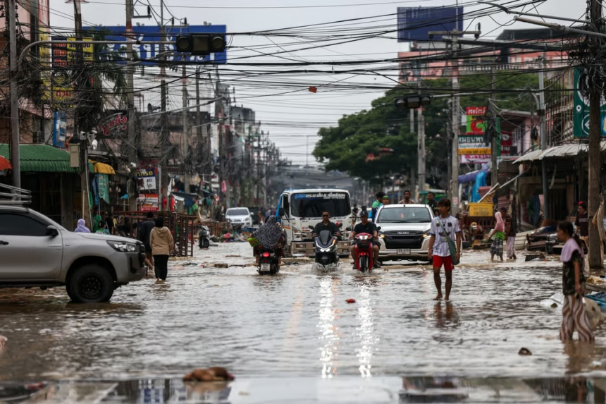
Where in Bangkok are you most likely to encounter flooding, and what causes it? Risk varies by neighborhood and storm: low-lying areas and known flood points may face repeated exposure, while other roads flood mainly when intense rain overwhelms drains and canals. A district name alone can’t tell you whether a particular street will flood.
The difference matters when you’re choosing where to live, planning a route, or checking a flood alert. Bangkok’s terrain, drainage limits, and rising river levels all shape local risk, so the hotspots aren’t one fixed citywide ranking. Start with the distinction between recurring flood areas and roads that collect water after heavy rain, including streets hit by torrential rain across Bangkok.
Key Takeaways
- Don Mueang, Lak Si, Bang Khen, and Sai Mai are recurring northern hotspots, while Min Buri, Lat Krabang, and Nong Chok face risk along Bangkok’s eastern fringe.
- On the west bank, low-lying districts such as Bang Phlat, Bangkok Noi, and Taling Chan can flood during prolonged rain or high Chao Phraya River levels.
- Flooding also affects central roads and canal corridors when intense downpours overwhelm local drains; Bangkok’s drainage tunnels and pumping stations help move excess water.
- A district label can’t predict conditions on every street. Check current local alerts, and see district-level flood-risk research for broader patterns.
Which Bangkok Districts Flood and Why
Bangkok’s recurring flood exposure is concentrated in low-lying western and eastern areas, while northern and central districts have known hotspots that flood during heavy rain. These patterns identify areas to watch, not streets that flood during every storm; conditions can vary sharply within one district.
Western Bangkok faces river, canal, and lowland risks
On the Thonburi side, Bang Phlat, Bangkok Noi, Bangkok Yai, and parts of Taling Chan sit near the Chao Phraya River and a network of canals. When river levels rise, water can push into low-lying communities, especially where barriers are limited. During long periods of rain, canals and drains also have less room to carry runoff away.
Farther west, Thawi Watthana, Nong Khaem, and Bang Khae include low ground and former paddy land, where flat terrain can slow drainage. Flood defenses have been reinforced around riverside communities such as Ban Bu and Wat Wimuttayaram, but nearby streets can still face different conditions depending on elevation and protection. Proposed Chao Phraya flood-management projects reflect the wider challenge of managing water across the river basin.
Eastern districts can pond after prolonged rain
Lat Krabang, Min Buri, Nong Chok, Prawet, and outer Bang Na face a different pattern. Their flat terrain, canals, and drainage channels can leave water standing when seasonal rain persists or a downpour exceeds the capacity of local drains. Some areas also sit farther from central drainage infrastructure, so runoff may take longer to clear.
Risk varies from one neighborhood to the next. A raised road or well-drained residential area may stay passable while a nearby low intersection collects water. Research on flood hazard mapping in Bangkok also highlights how local terrain and drainage shape exposure, rather than district boundaries alone.
Northern and central districts have recurring local hotspots
Don Mueang, Bang Khen, Chatuchak, and Lat Phrao appear in reports of recurring waterlogging, but that doesn’t mean entire districts regularly go underwater. Heavy rain can overwhelm drains at particular intersections and road corridors. Examples include Ratchadaphisek Road near Bangkok Bank in Chatuchak and Chaeng Watthana Road in Lak Si.
Canals and low-lying road connections can add to the problem, while central areas such as Phra Khanong may also see localized ponding after intense rain. The practical distinction is repeated exposure in known low spots versus temporary street flooding when a storm outpaces drainage. Check conditions at the neighborhood or route level, not just by district name.
Central Bangkok Streets Can Flood Even Outside Chronic Risk Zones
A district can have relatively low chronic flood exposure and still contain streets that flood during a severe downpour. In central Bangkok, water may collect at one low point or junction while nearby blocks remain passable, so neighborhood-wide labels can miss the risks commuters face on a specific route.
Why roads and underpasses can flood so quickly
A cloudburst sends runoff onto paved streets faster than local drains can carry it away. If water also backs up at a canal crossing or a pump cannot clear a low point quickly enough, one stretch of road may become impassable before nearby streets show any standing water. Underpasses are especially exposed because they sit below surrounding road level and funnel runoff toward the lowest point.
Traffic corridors can have the same problem. Dense development leaves little open ground for water to soak into, while heavy traffic may slow or block access for drainage crews. Bangkok’s drainage system includes different levels of pipes for major and ordinary roads, as outlined in this UN ESCAP overview of flood management in Bangkok. Even with pumps and drainage infrastructure, intense rain can briefly exceed what a local segment can handle. The result may be short-lived street flooding rather than the prolonged inundation associated with chronic risk areas. Similar low points can become hazards during high tides, too, as Bangkok road flooding during high tides illustrates.
Treat flood-prone lists as local warnings, not district-wide predictions
Bangkok flood-prone lists don’t all use the same year, counting method, or purpose. Some identify specific road segments for drainage response, while others summarize broader exposure. Their examples are best read as local warnings, not proof that an entire district floods regularly.
BMA-identified trouble spots include Chan Road and Sathu Pradit in Sathorn, Sukhumvit Soi 39 and 49 in Watthana, and Phahonyothin Road in Phaya Thai. Reports also identify vulnerable road sections around Ratchathewi, Din Daeng, and Phra Nakhon. Elsewhere, Bang Na Nok, Sanphawut Road, and Srinakarin Road appear among areas to watch. A listing points to particular segments or low spots, not every street nearby.
Conditions can change as the Bangkok Metropolitan Administration clears drains, adjusts pumps, or completes drainage work. Therefore, use flood-prone lists to identify places that may need extra caution, then check current rainfall and road updates before traveling. A street’s risk depends on the storm and the condition of its local drainage, not only its district name.
The Main Reasons Bangkok Floods
Bangkok flooding usually results from several pressures arriving at once. Heavy rain adds water faster than drains can move it, while river levels, tides, and low terrain can slow its route out of the city.
Heavy rain can exceed the city’s drainage capacity
A brief, intense downpour can overwhelm street drains and pumps before they clear the first surge of runoff. Prolonged rain creates a different problem: canals remain high, and low-lying areas may take longer to drain even after the heaviest rainfall ends. As a result, one street can flood quickly while another nearby stays passable.
The Bangkok Metropolitan Administration prepares for these conditions by clearing drains and canals, checking for blockages, and readying pumps. Its canal and drain cleaning work is part of BMA flood preparation. These steps help water flow, but they can’t prevent all ponding when rainfall exceeds local capacity.
High river levels and tides can push water into low areas
Bangkok’s canals connect neighborhoods to the Chao Phraya River, so river conditions can affect how quickly water leaves riverside communities. When upstream discharge raises the river and high tides slow its flow toward the sea, connected canals may also rise. That can limit drainage or increase pressure on low areas near the river.
However, river-adjacent districts don’t all flood at once. Local elevation, flood barriers, canal connections, and the timing of rain and tides all shape which places are affected. Monitoring rising Chao Phraya water levels can help explain alerts, but conditions still vary by neighborhood.
Flat, low land leaves water with fewer ways to drain
Much of Bangkok sits on low, flat land, where gravity moves water away slowly. Canal-side development and paved surfaces can also reduce space for water to spread or soak into the ground. Areas that once held water may now have buildings and roads, leaving runoff fewer places to collect safely.
Subsidence adds another concern because gradual ground sinking can worsen drainage challenges in some places. Its effect varies, so it shouldn’t be treated as the cause of every flood. In practice, a low street, heavy rain, and a high canal can combine to keep water standing longer than any one factor would alone.
How to Check Flood Risk Before Choosing a Route or Neighborhood
A district’s flood history can point you toward areas to check, but it can’t tell you whether a particular building or street will flood. Before you rent, buy, or travel, look up the exact location and check conditions again after heavy rain.
Check official maps, alerts, and recent local reports
The Bangkok Metropolitan Administration’s flood-risk dashboard maps known flood points and mitigation work, giving you a useful starting point for comparing neighborhoods. You can explore the BMA flood-risk data platform alongside BMA updates from its Drainage and Sewerage Department, public relations channels, and Bangkok.Water. These resources can help distinguish a known hotspot from a place where crews have recently improved drainage.
However, a map shows risk patterns, not live conditions. During the rainy season, check official alerts before setting out, then check again after intense rainfall because road access can change quickly. Recent local reports can also reveal which intersections or routes are affected. For broader context, see this Thailand flash flood warning, but use current BMA updates to verify conditions in Bangkok.
Use street-level clues when comparing places
When you assess a home or route, look beyond the district name. Check whether it sits near a canal or river, at the bottom of a slope, or beside a low underpass. Search the street name with terms such as “flood” or “waterlogging” to find reports about recurring trouble spots.
Then ask people who know the block. Residents, building managers, and shop owners can explain how deep water gets, how long it usually stays, and whether nearby access roads become impassable. Their experience can reveal practical details a map won’t show, such as whether a building entrance stays dry while the nearest bus stop floods.
If you’re choosing a place to live, check the route to transit, work, and essential services, not just the property itself. A home may remain dry while the only connecting road collects water. For visitors, confirm the latest road conditions before taking a low-lying route, especially after heavy rain.
Frequently Asked Questions
Bangkok flood risk can affect daily plans in ways that district-level maps don’t show. These answers cover practical concerns about travel, water levels, and choosing a place to stay.
Can flooded roads affect BTS or MRT trips?
Yes. A train line may continue operating while nearby roads, sidewalks, or station approaches become difficult to reach. After heavy rain, check your full route, including the walk or ride to the station, and allow extra time.
How long does street flooding usually last?
There’s no reliable fixed timeframe. Water may clear once rainfall eases and drains or pumps can move it, but high canal or river levels can slow that process in some locations. Conditions can also differ between nearby streets.
Is it safe to drive or walk through floodwater?
Avoid walking or driving through water when you can’t judge its depth or see the road surface. Floodwater can conceal open drains, debris, or other hazards, and vehicles can stall in standing water. Choose a dry alternative and follow local instructions.
What should I ask a landlord about flood protection?
Ask whether the building or its entrance has flooded before, how water is kept out, and whether pumps or backup power are available. Also check whether the building’s access roads and nearby transit routes remain usable during heavy rain.
Where can I check for heavy-rain warnings?
Check current Bangkok updates and broader advisories before traveling, since warnings can change with rainfall and river conditions. The FEWS-Bangkok forecasting system uses water and rainfall information to support flood forecasting, while Thailand’s heavy-rain and flood alert coverage offers an example of time-sensitive warnings. Verify any alert with current official updates before making plans.


