
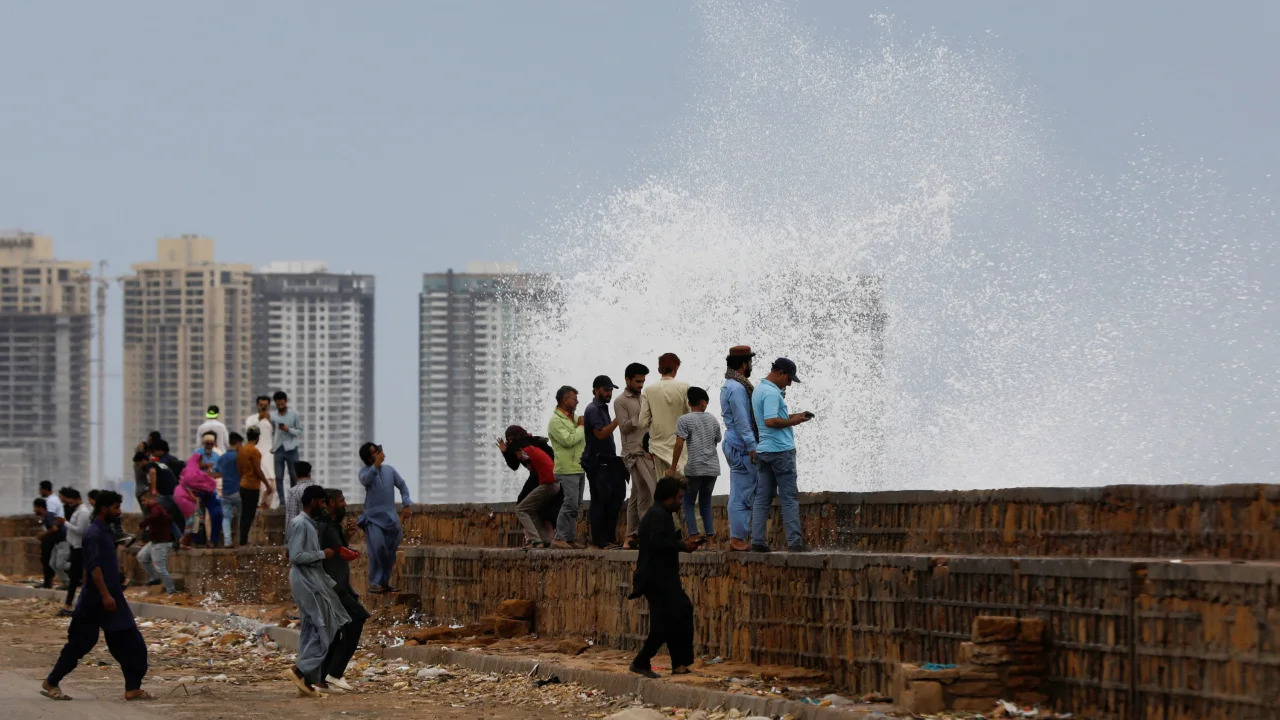
(CTN NEWS) – Cyclone Biparjoy, which is predicted to make landfall between Keti Bandar in Sindh and Kutch in Indian Gujarat tomorrow (Thursday), is heralded by strong winds, showers, and high seas.
The Pakistan Meteorological Department (PMD) predicts storm surges up to 3.5 metres high at the site of landfall, which may flood low-lying coastal communities.
Cyclone Biparjoy Maximum Speed
The effect would be exceptionally severe seas off the shores of Sindh and Balochistan.
In India’s Kutch and Rajkot districts, three people perished on Tuesday, while four boys drowned in Mumbai and hundreds of people were evacuated from Pakistan’s shore and India’s coastal areas.
The very severe cyclonic storm’ known as Biparjoy made landfall over the northeast Arabian Sea.
The cyclonic storm had moved farther north/northwestward and was only 380km south of Karachi, according to a PMD advisory issued on Tuesday night.
Maximum sustained surface wind speeds are estimated to be between 140 and 150 kph, up to 170 kph around the system’s centre.
According to the current upper-level steering winds, Biparjoy is most likely to continue moving north until June 14 morning, then re-curve northeastward and cross between Keti Bandar (southeast Sindh)/
And the Indian Gujarat coast on June 15 afternoon/evening as a very severe cyclonic storm with packing winds of 100-120kmph gusting 140kmph, according to the alert.
The cyclonic storm is expected to cause extensive wind and dust storms, as well as thundershowers, in the districts of Thatta, Sujawal, Badin, Tharparker, Mirpurkhas, and Umerkot until Friday based on its present trajectory.
These might come with gusty winds that reach 120 kph.
Between now and Thursday, similar weather conditions and squally winds of 60 to 80 kph are predicted to affect Karachi, Hyderabad, Tando Muhammad Khan, Tando Allayar, Shaheed Benazirabad, and Sanghar.
Cyclone Biparjoy Expected Intensity
Previously classified as an extremely severe cyclone storm, it became a very severe cyclonic storm on Tuesday night and proceeded from the east to the northeast of the Arabian Sea.
Chief Meteorologist Dr. Sardar Sarfaraz explained this change by stating that “this change… only represents reduced speed of the winds surrounding the system, but the cyclone is still severe and can cause a lot of damage especially in areas that would be directly hit.”
He also noted that the cyclone was less severe than the cyclone in 1999.
When asked about the amount of predicted rainfall, he responded, “It could be 50-60mm within 24 hours.”
Cyclone Biparjoy Information Shared By The Sindh CM House
According to information provided by the Sindh CM House, as of Tuesday evening, 56,985 out of the 71,380 total vulnerable population—residencing in seven talukas across three districts—had been evacuated.
Of these, approximately 22,000 persons chose to leave on their own. The Thatta district’s Keti Bundar and Ghora Bari, the Sujawal district’s Shah Bundar, Jati, and Kharochann, the Badin district’s Shaheed Fazil Rahu tehsil, and Badin all saw evacuations.
37 relief camps have been established in various locations, including government schools and colleges.
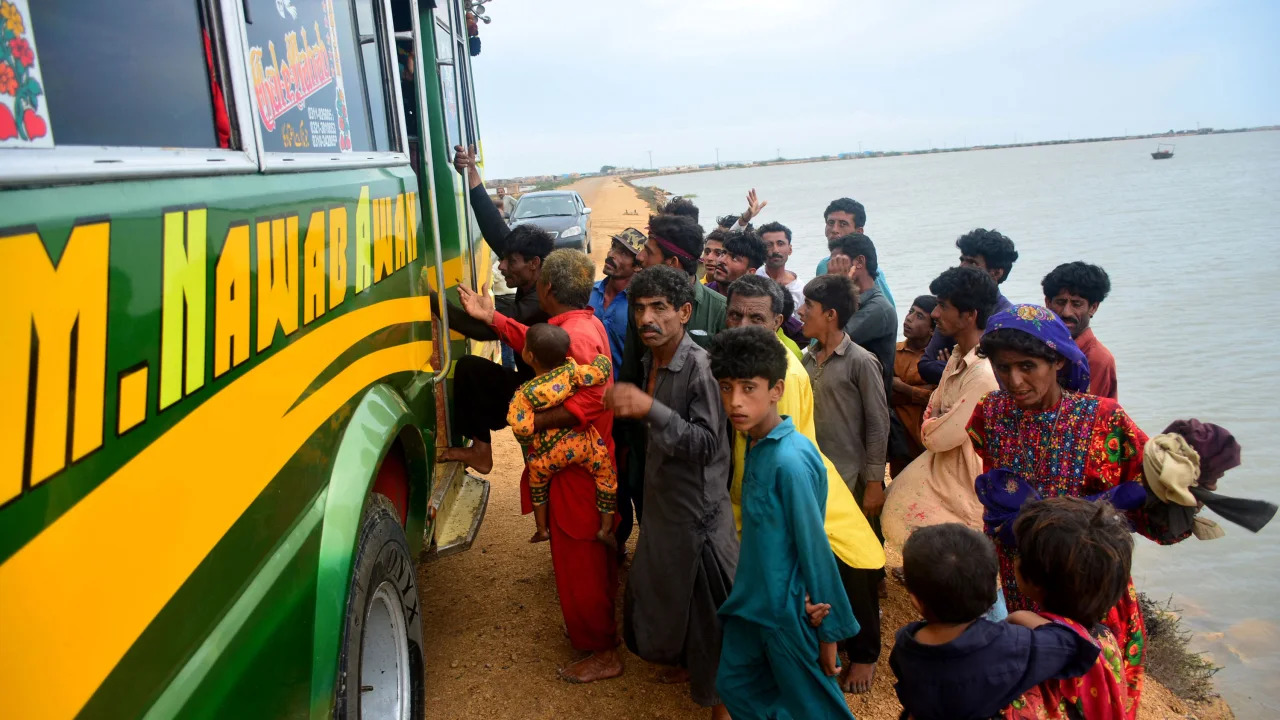
According to the Pakistan Navy, troops have evacuated 700 people from several Shah Bandar villages, and 64 fisherman have been saved from the water.
A cyclone monitoring cell has been created at Headquarters Commander Karachi, and the PN Joint Maritime Information Coordination Centre is regularly disseminating information to all stakeholders.
Particularly the fishing community, according to a statement from the organisation.
While naval ships were keeping watch in the open sea, naval emergency response and medical teams had been stationed in rural Sindh, including Hyderabad, Shaheed Benazirabad, Sukkur, and Sanghar, as well as coastal Balochistan.
Federal Surveillance
Separately, Sherry Rehman, the minister responsible for climate change, urged people to maintain their composure and noted that the federal government was working with the governments of Sindh and Balochistan.
While the prime minister was overseeing risk mitigation and reduction efforts and had ordered all relevant ministers to remain involved continuously until the emergency is resolved.
People in Kund Malir, Hub, Lasbela, and Winder are urged to exercise caution despite the cyclone’s lessened intensity, which is just on the Balochistan side.
Keep your guard up and don’t disregard the early indications, she pleaded.
According to Ms. Rehman, the cyclone’s strength may change, especially near the coast of Sindh, and Karachi is likely to see urban flooding with up to 100mm of rain.
She added that it is hoped that the evacuations will be effectively finished by June 14, before the predicted landfall of the typhoon.
Lahore or Multan would be utilised as backup airports for flights to Karachi and Sukkur in case of inclement weather, according to the national flag carrier, PIA.
RELATED CTN NEWS:
White House Bans ‘Rose Montoya’ Trans Activist For Topless Videos At Pride Event
The Implications Of The Donald Trump Court Hearing: Key Takeaways
Flag Day 2023: When Is It? Is it A Holiday? Why Do We Celebrate It?

