
(CTN News) – Over 70 million Americans are at risk of severe thunderstorms from Nebraska through much of the Southern Plains and Midwest between Monday and Wednesday.
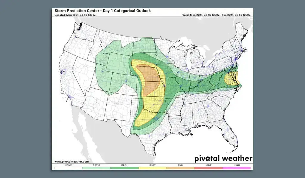
Coastal Virginia is also at risk for severe weather from the National Weather Service’s Storm Prediction Center, which has issued an enhanced risk (level 3/5) of severe thunderstorms for much of Kansas and Nebraska on Monday.
Many parts of Pennsylvania were affected by a line of damaging severe thunderstorms on Sunday evening. This was an unusually early occurrence for such a damaging line of storms so far north and east, although April is traditionally the start of severe weather season in much of the United States.
The National Weather Service (NWS) warned that thunderstorms could bring large hail, damaging winds, and a few tornadoes to the Plains and parts of the Mid-Atlantic coast on Monday morning.
In spite of the fact that large hail doesn’t receive the same amount of attention as tornadoes, large hail can cause substantial economic losses due to the destruction of cars, homes, and crops.
A large number of such losses occurred in the United States last year, resulting in billions of dollars in losses to insurers across the country.
It is expected that showers and thunderstorms will develop across the Great Plains on Monday afternoon and that the severe weather threat will persist into the evening, when scattered to severe thunderstorms are likely to develop across the Southern to Central Great Plains, according to the SPC.
Accordingly, the NWS reports an enhanced risk of severe storms in western Oklahoma and northwest Texas, “partly due to the threat of large to very large hail, damaging wind gusts and a few tornadoes.”
In the Great Plains, a slight risk (level 2/5) was in effect.
As a result of an intensifying deep Great Plains storm, severe weather threats are forecast to shift eastward on Tuesday. Showers and thunderstorms will extend into the Mississippi Valley as a result of the warm sector of the storm.
Early afternoon, storm chances increased from Washington, D.C., northward to Richmond as a result of a frontal zone and strong winds in the mid-to-upper atmosphere.
A low pressure system is forecast to surge northward out ahead of an area of moisture and warmth, causing unusually high air temperatures across the Plains and into the Midwest.
Throughout the severe weather region, and indeed throughout a broader area, high temperatures in the 80s and even 90s are expected.
We are watching: The SPC noted in its discussions that the exact extent and severity of the tornado risk was uncertain. The ingredients for a widespread severe weather outbreak appeared to be present from Nebraska into Texas moving eastward with time on Monday and Tuesday.
SEE ALSO:
Treasury Says IRS Funding Of $80 Billion Will Boost Response in 2024


