
CHIANG RAI – The Department of Public Works has joined forces with the Community Organizations Development Institute to fast-track the study and planning process for relocating 1,500 households in Mae Sai. The homes lie within the proposed flood barrier zone, which will involve a 2,000-million-baht investment.
The project will tackle the bottleneck issue by widening the Sai River by 50 metres to help resolve flooding in Mae Sai for good. Authorities also plan to implement the Ban Mankhong Housing Project on 70 rai of former tobacco factory land, creating a new community space.
Phongnara Yenying, Director-General of the Department of Public Works and Town & Country Planning, told Prachachat Business that the major flood in Mae Sai, Chiang Rai, in October 2024 caused over 6 billion baht in economic losses.
The department was tasked with developing a long-term flood protection plan. The solution focuses on building a flood and mudslide barrier along the Sai River and upgrading checkpoint areas near the first and second Friendship Bridges, covering 3,960 metres. This work will require roughly 2 billion baht.
The government has allocated central funding so the department can complete a construction plan within one to two months. The main focus must be on shifting communities currently occupying the riverbanks to pave the way for construction.
The initial studies show that demolition of over 843 houses will be needed, along with land acquisition following the flood barrier’s route. Of these, 178 homes are on titled land, 162 lie on state property, and 503 are on public land. The impacted area totals 275 rai, with 158 land plots carrying title documents, three parcels registered as state property, and 196 rai being public space.
Residents Agree to Relocate
Phongnara explained that affected residents will receive compensation. Chiang Rai Province has teamed up with the Community Organizations Development Institute (CODI) to help secure land for Ban Mankhong, a project like the canal development in Bangkok, so local riverside families can rent land from the Treasury Department.
This ensures safe, legal housing. Home construction costs will be covered by long-term cooperative loans, which residents can repay through instalments. The flood barrier is a long-term project, and the relocation of 843 households cannot be finished within this rainy season or the next.
Most residents, after discussions, have agreed to relocate. Phongnara is confident the department’s method can fix Mae Sai’s flooding issues for good because the plan is built on data and solid engineering. With funding ready, construction can start as soon as the residential relocation is complete.
After the study wraps up, the department will meet with locals and stakeholders to discuss any impacts and negotiate with landowners about using their land for the barrier. A committee will set fair prices for land and buildings affected by construction, using a mediation approach. If agreements cannot be reached, a royal decree for expropriation will move the work forward.
Those with land and house ownership documents will receive full compensation, covering both property and structures. Where only the house is affected, such as on public land, compensation will match the home’s assessed value. Early estimates put reconciliation spending at around 200 million baht, to be proposed by the department as part of the central government budget.
Widening the Mae Sai River
Phongnara added that the riverbank barrier and bridge improvements will require 2 billion baht for the 3,960-metre stretch, split into two phases. The first phase covers from Ban Tham Pha Chom to Irrigation Office Two (1,930 metres) through community zones, affecting 120 homes.
Starting at Thetsaban 21 Road near the Muang Daeng weir, the route will expand the road by around 400 metres and connect to the border checkpoint, with a new 480-metre section joining Ko Sai Road and running up to the irrigation department’s road. The second phase runs another 2,030 metres through the irrigation office land up to the second border checkpoint.
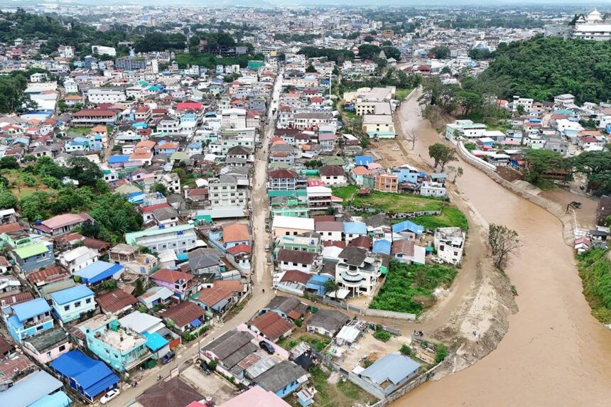
Previously, the Sai River measured between 70 and 80 metres wide, but has now narrowed to less than 20 metres, especially where it passes through Mae Sai town. The reduced width only allows water to flow at about 100 cubic metres per second, but last October, rates surged to over 400 cubic metres per second, flooding the area. The new barrier will step back 20 to 30 metres from the river, expanding it to at least 50 metres wide.
Plans call for a raised barrier two metres high with an added one-metre reinforced concrete wall, giving a total of three metres in height and nine metres across. This barrier is designed to handle water flows up to 430 cubic metres per second. Upgrades will include new road construction and improvements to the existing riverside road, turning it into an extra defence line with big bags as backup.
The space outside the barrier will be renovated into parks, car parks, and event grounds. These areas will serve as water catchments during rainy spells, similar to practices in Japan. Throughout construction, authorities will keep talking with any outlying residents. Owners with land titles will get land and building payments, while those without land rights will get house compensation only, keeping negotiation first in every scenario.
1,500 Mae Sai Families Need to Move
Wichien Polsayom, director of CODI’s northern office, said his team recently met with the deputy governor of Chiang Rai, the Mae Sai district chief, and administrators from three subdistrict municipalities to start designing both the process for moving residents and setting up the Ban Mankhong homes.
They viewed 70 rai of former Tobacco Monopoly land, now a health park, located 1.5 kilometres from the checkpoint and just 300 metres from the district office. This site is never exposed to flooding.
Approvals will be needed from all relevant agencies. Once studies finish, Chiang Rai’s provincial committee, chaired by the governor, must review the plan as it connects many agencies. CODI’s director will also review the plans before passing them to the Ministry of Social Development and Human Security for cabinet review.
Locally, a working group will check the details on the roughly 1,500 families needing to move back at least 40 metres from the Sai River. Each household’s record will be checked for ID registration status and nationality to help with planning the new community layout. The findings will be sent to CODI management and the ministry for land-use authorization.
Associate Professor Dr. Sutthisak Soralum, a civil engineering lecturer at Kasetsart University, is on board to analyze the area and help explain flood risks and project steps to residents. As the study progresses, the results will go to the Chiang Rai disaster management board for a final decision. Wichien stressed they are not forcing anyone to move, but moving is needed for long-term safety and development, making this a large undertaking that takes time.
Ban Mankhong’s community layout will be based on residents’ preferences, whether for row houses, semi-detached homes, or detached houses. State-run financial institutions and CODI will provide financing, and priority goes to ID-card-holding Thais and their extended families, based on local approval.
Houses under the Ban Mankhong scheme come in various sizes. Those joining must make instalment payments to the bank. Small row houses, similar in size to projects along Bangkok’s Lat Phrao and Prem Prachakorn canals, will cover up to 30 square metres, with construction costs between 280,000 and 300,000 baht.
In rural areas, larger communal spaces may push that figure to about 350,000 baht, and for five-person families, budgets could reach 350,000 to 400,000 baht.