


MANILA – Airlines have suspended flights as Super Typhoon Uwan, classified as a potent Category 4 storm, nears the eastern side of the Philippines on Sunday. It’s carrying destructive winds that could reach 220 kilometers per hour.
The Philippine Atmospheric, Geophysical and Astronomical Services Administration (PAGASA) warned that conditions would be “life-threatening.” Super Typhoon Uwan is the 21st storm of a severe 2025 season and is moving toward a possible devastating landfall in central Luzon.
The nation is still recovering from Typhoon Tino, which claimed over 200 lives earlier this month. Uwan threatens to worsen the situation, leading to widespread flight cancellations and a massive government effort.
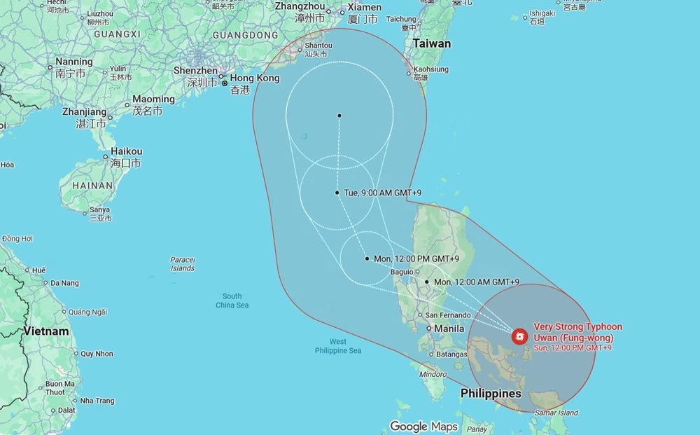
As of Sunday morning, Uwan’s center was just off the coast of Catanduanes. It was hitting the Bicol region with Signal No. 5 warnings, the highest alert level. This level warns of “extreme impacts” from the powerful winds.
PAGASA’s most recent statement, released at 11 a.m., placed the super typhoon about 125 kilometers east-northeast of Virac, Catanduanes. The storm moved west-northwest at 25 kph.
Because the storm is so large, covering hundreds of kilometers, its intensity has spread to the Visayas and some parts of Mindanao. These regions are under Signal No. 1 advisories, meaning minimal or minor threats, but ongoing heavy rainfall.

Airlines Halt Operations Due to Safety Concerns
The Civil Aviation Authority of the Philippines (CAAP) reported on Saturday that poor weather forced more than 300 domestic and international flights scheduled for November 9 and 10 to be canceled. See flight cancellations here.
This left tens of thousands of travelers stuck at major hubs, including the Ninoy Aquino International Airport (NAIA). Philippine Airlines (PAL), the country’s main carrier, stopped operations on over 25 domestic routes, including important services to Cebu, Laoag, Tuguegarao, and Naga. A PAL representative said that traveler safety remains the highest concern.
The spokesperson asked affected passengers to check the airline’s website for ways to rebook their flights.
Cebu Pacific, the leading low-cost airline, faced the biggest impact with over 85 cancellations. These mainly affected flights to and from Manila, Clark, and regional spots like Legazpi and Virac. Cebgo, the subsidiary, added another 34 interruptions, affecting routes to Iloilo and Bacolod. AirAsia Philippines and AirAsia Malaysia together canceled numerous Manila-bound international and domestic trips.
They called these “proactive measures” against the severe weather expected. AirAsia’s head of communications expressed regret for the trouble but stated that safe travel is the priority.
CAAP’s list was updated at 7 a.m. Sunday and included suspensions at Bicol airports (Daraga, Masbate, and Virac). These stops took effect from 4 a.m. Operations were stopped using Notices to Airmen (NOTAMs). Other airlines, such as Sunlight Air and SkyJet, reported only minor changes.
However, the majority of the disruption came from the three main carriers: PAL, Cebu Pacific, and AirAsia. Travelers should check CAAP’s flight advisory page (https://caap.gov.ph/flight-advisories) for immediate updates. More changes are likely if Uwan changes course unexpectedly.
These cancellations are similar to the disruption caused by Typhoon Tino, which stranded 1,800 passengers after grounding flights. This time, Uwan rapidly increased in strength, changing from a severe tropical storm to a super typhoon in less than 48 hours. Airlines responded quickly, offering complete refunds or free rescheduling.
Still, the news came as a hardship for many Filipinos planning family trips or urgent travel. Ana Reyes, a traveler at NAIA Terminal 3, looked worried because her flight to Cebu was canceled. She said they are stuck in Manila, waiting for the storm to pass.
Typhoon Uwan Path: Catanduanes and Central Luzon Face the Storm
PAGASA predicts that Uwan’s center will brush past Catanduanes this morning, coming very close to Calaguas and Polillo Islands by this afternoon. It is then expected to hit the middle part of Aurora province late Sunday night or early Monday morning, November 10.
There is also a chance of a direct hit on southern Isabela. The storm’s eyewall, the most violent section, is set to strike these areas at full strength. After crossing Northern Luzon’s Sierra Madre mountains, Uwan should weaken. However, it is expected to emerge over Lingayen Gulf or the Pangasinan-La Union coasts as a still-powerful typhoon, creating surges up to 5 meters high.
The path of the typhoon has been confirmed by the U.S. Joint Typhoon Warning Center and Japan’s Meteorological Agency. It signals major trouble for low-lying communities along the eastern coast. In Catanduanes, over 300 people have moved to shelters such as Pandan Parish Church, where floodwaters already reach the doorways.
Flooding has affected Caramoan in Camarines Sur and Daraga in Albay, while huge waves crash against Masbate’s shores. PAGASA urges residents along the coast to follow evacuation orders (https://bagong.pagasa.dost.gov.ph/tropical-cyclone) right away. They warn of widespread flooding, landslides, and storm surges far from the storm’s immediate path.
Northern and Central Luzon face the most serious threat. Signal No. 4 is already active over Quirino, northern Nueva Ecija, and eastern Isabela. Metro Manila, under Signal No. 3, should prepare for 100-200 millimeters of rain daily. This could cause flash floods in urban areas like Marikina and Pasig. The Visayas, although avoiding the storm’s eye, deal with Signal No. 2 rains that could cause rivers to swell in Samar and Eastern Samar.

Philippines Evacuations, Alerts, and Aid Efforts
President Ferdinand Marcos Jr. has put the country on high alert. He directed all government offices to make the storm’s impact less severe. The Department of the Interior and Local Government (DILG) ordered local government units (LGUs) to finish moving people out of high-risk areas by Sunday evening.
This effort targets over 100,000 residents in Bicol and eastern Luzon. DILG Secretary Jonvic Remulla stressed during a briefing that the next 48 hours are critical, urging people to act now.
The Philippine Coast Guard (PCG) has sent 547 personnel, 18 vessels, and nine vehicles throughout Bicol. Response teams are ready in Catanduanes, Sorsogon, and Masbate. Other units are moving to Camarines Norte and Sur for rescue operations. The Philippine National Police (PNP) activated full disaster preparedness protocols.
The Department of Transportation (DOTr) prepared buses and trucks for evacuations and aid delivery. Metro Manila’s local councils, led by San Juan Mayor Francis Zamora, are stocking up on rescue supplies (PVC boats, generators, life vests) at MDRRMO headquarters.
The Department of Social Welfare and Development (DSWD) is putting together family food packs at its Luzon Resource Center. They have already positioned 1.2 million packs nationwide. Classes and government work have been suspended in Luzon, Visayas, and part of Mindanao through Monday, based on orders from Malacañang.
The National Disaster Risk Reduction and Management Council (NDRRMC) manages the coordination from Camp Aguinaldo. The council urges citizens to follow PAGASA updates (https://bagong.pagasa.dost.gov.ph) and avoid travel.
As Uwan makes landfall, the determination of Filipinos is evident, even through the storm. From the flooded streets of Bicol to the worried airport terminals of Manila, the archipelago is united in its preparedness.
Experts caution that climate change makes these storms stronger. Hotter oceans provide more energy for severe rain. This year’s 21st cyclone may mark a difficult new standard. For now, preparation and hope are the country’s best defense.