


A moderate cool air mass is expected to move in from February 1 to February 4, bringing cooler mornings to many areas and fog that can be thick in places. The Nation’s report says the Northeast should see a 1 to 2°C dip, even if afternoons stay warm. Bangkok and several regions may also experience morning fog, with visibility dropping quickly on some roads.
Air quality is another concern. The same report warns PM2.5 will be moderate to high in the North and Central (including the capital area) and the East because winds stay light and dispersion is weak. At sea, conditions turn choppier in the lower Gulf, with waves around 1 to 2 meters.
At a glance
- Timing: Cooler air is expected from Feb 1 to Feb 4, with signs starting tonight (Jan 31).
- Main areas: Upper regions plus the capital area see cooler mornings and fog risk.
- Temperature: Northeast dips 1 to 2°C (per The Nation).
- Fog risk: Morning travel may be hazardous where fog turns thick.
- Air and sea: PM2.5 may build up, lower Gulf seas become rougher (1 to 2 m).
What’s happening in the Feb 1 to Feb 4 weather shift
This system is linked to higher pressure and cooler air moving down from southern China, passing across parts of northern Vietnam and the South China Sea before spreading into the upper parts of the country. When cooler, drier air slides over warmer, humid ground, mornings often feel cooler first, and fog becomes more likely in low-lying areas.
The Nation’s report places the main impact from Feb 1 to Feb 4, and highlights a 1 to 2°C drop in the Northeast. That change may sound small on paper, but it often shows up in daily life as a sharper chill just before sunrise, then a quick warm-up after mid-morning.
A simple planning timeline helps, because these events can feel confusing when afternoons stay hot:
- Tonight (Jan 31): The leading edge approaches the upper Northeast, and fog risk increases in some areas.
- Feb 1 to Feb 4: Broader impact across upper areas, with cooler mornings and more widespread fog risk.
- Typical fog hours (general pattern): Fog often peaks between 5:00 a.m. and 9:00 a.m., though it can form earlier or clear later, depending on local wind and humidity.
For background on how these cool surges behave around the capital region, see this related explainer on Bangkok cool surge timing and morning conditions.
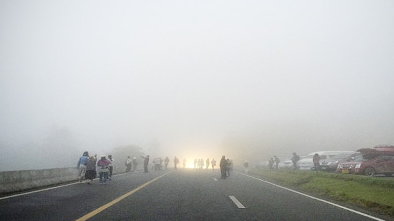
Bangkok morning fog and how to travel safely when visibility drops
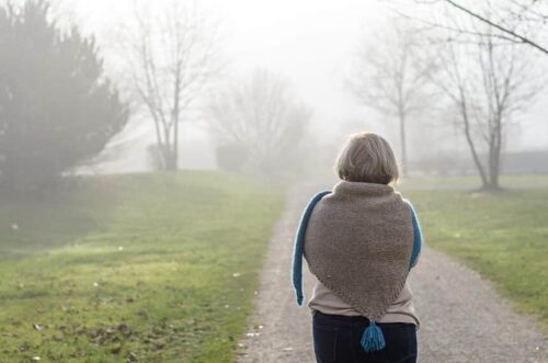

During the forecast window from 6:00 p.m. Jan 31 to 6:00 p.m. Feb 1, the capital area is expected to experience cool morning conditions and fog. Fog is simply a cloud at ground level. It forms when air near the surface cools enough for water vapor to condense into tiny droplets, which scatter light.
In practice, visibility can drop quickly in some areas, even when nearby streets appear clear. Low-lying stretches near canals, open fields on the outskirts, and roads beside water often see thicker patches. Overpasses and bridges can also feel slick at dawn due to dew.
The key risk is timing. The school run, airport trips, early shift work, and delivery routes often happen during the same hours when fog is most likely. Bangkok morning fog can also hide a stopped vehicle until the last second, especially on higher-speed roads.
For commuters, the simplest approach is to plan for slower travel and fewer sudden moves. Motorbike riders should assume other drivers may not see them until very close, and choose brighter gear if available.
Quick fog safety rules for drivers and riders
- Slow down before entering a fog bank, not after.
- Leave more following distance than usual.
- Use low beams, high beams can reflect back and reduce visibility.
- Avoid sudden braking, ease off the accelerator early.
- Use hazard lights only when stopped or if traffic is fully crawling.
- Watch for parked vehicles, especially on shoulders and slip roads.
- Add time to the trip, rushing causes most fog-related mistakes.
The Nation also advised caution where fog becomes thick; the safest trips are the ones that assume visibility can change without warning.
Regional forecast you can scan fast (18:00 Jan 31 to 18:00 Feb 1)
Below is the Thai Meteorological Department forecast window from 18:00 Jan 31 to 18:00 Feb 1, presented in a quick scan format for planning.
| Region | Low / High range | Main risk | Who should care |
|---|---|---|---|
| North | 14-17°C / 31-34°C (mountains 5-13°C) | Morning fog (some thick) | Drivers, riders, early markets, hill travel |
| Northeast | 14-19°C / 32-34°C (mountains 9-15°C) | Morning fog, 1 to 2°C dip | Students, outdoor workers, long-distance drivers |
| Central | 18-20°C / 34-35°C | Morning fog (some thick) | Commuters, school transport, logistics |
| East | 20-23°C / 32-35°C | Light morning fog, slight coastal rain | Coastal drivers, small boats, outdoor crews |
| South (East coast) | 20-22°C / 31-34°C | Slight rain in some areas | Island trips, ferries, beach operators |
| South (West coast) | 22-25°C / 33-35°C | Light rain in some areas | Tour boats, coastal travel, fishing crews |
| Bangkok and vicinity | 22-24°C / 33-35°C | Morning fog | Commuters, early flights, school runs |
For official updates, the Thai Meteorological Department posts daily national outlooks at its Thailand daily weather forecast page.
What the Northeast temperature dip means for daily routines
The temperature drop in Northeast Thailand (1 to 2°C, as reported by The Nation) is most noticeable at the start of the day. Mornings can feel cool in shaded areas, then the heat returns quickly by late morning. That day-to-night swing also affects comfort, sleep, and outdoor work.
For families, a small change often leads to big complaints: kids may feel cold on the way to school, then sweat by lunchtime. A thin, removable layer is more effective than heavy clothing.
Older adults may feel the chill more, especially before sunrise. Warm drinks and keeping the bedroom from getting too cold can help, and people with joint pain may notice the difference early in the morning.
Outdoor workers should plan for two hazards simultaneously: cooler dawn air and surface moisture. Bridges, flyovers, and shaded concrete can turn slick from dew. A slower start, better footwear, and a few extra minutes before climbing ladders or loading trucks can prevent injuries.
Haze and PM2.5, why it can get worse during calm mornings
PM2.5 is fine dust small enough to enter deep into the lungs. When wind is light and the atmosphere stays stable, pollution can linger close to the ground. That’s what forecasters mean by weak dispersion: the air doesn’t mix well, so smoke, vehicle exhaust, and other particles stick around.
The Nation reported PM2.5 is moderate to high due to weak air dispersion in the North and Central (including the capital area) and the East during this period. People may notice a dull sky, a mild burning smell in some places, or irritation in the throat and eyes.
This is also why haze can feel worse in the morning. Overnight cooling can trap a layer of polluted air near the surface, then it slowly breaks up later in the day as heating increases and winds pick up.
Those wanting local context on seasonal haze drivers can also read Northern region PM2.5 dust spikes and visibility impacts. Conditions vary by day and place, but the pattern of trapped morning pollution is common in the dry season.
A practical takeaway: PM2.5 levels in Bangkok can be higher on calm mornings, even if the day brightens later.
Health guidance for families, seniors, and people with breathing problems
Most people will be fine with basic precautions, but sensitive groups should treat hazy mornings like a “reduce exposure” day.
- Check official air quality alerts before outdoor plans.
- Cut back on outdoor exercise during hazy mornings, move workouts indoors if possible.
- If sensitive, wear a well-fitting mask designed for fine particles.
- Keep rescue inhalers and needed medicine close, not in a car or locker.
- Close windows during peak haze hours, then air out the home later when conditions improve.
- Use an indoor air filter if available, even a single room can help.
- Watch children and older adults for coughing, wheezing, unusual fatigue, or eye irritation.
- Seek medical care if breathing symptoms worsen or don’t improve.
For broader reporting on the early February cool shift, a secondary summary is available from cooler weather returning in February.
Sea conditions in the Gulf and Andaman, who should be careful
At sea, the pattern is tied to a weak northeast monsoon, which still increases winds enough to roughen waters in exposed areas. The Nation report notes little rain overall in the South, but sea conditions change faster than conditions on land.
Key points reported include:
- Lower Gulf waves around 1 to 2 meters
- Upper Gulf and the Andaman around 1 meter
- Offshore waves can be higher than near the coast
That matters most for small craft, fishing crews, ferry operators, and anyone running boat trips for tourists. Even when the sky looks fine near shore, a longer run offshore can meet rougher water and stronger gusts.
For trip planning, Gulf of Thailand wave height 1-2 meters is a useful threshold. Small boats may take spray over the bow, and passengers can face a rough ride, especially on open decks. Beach businesses should also plan for changing sea state, since fewer people choose boat tours when conditions feel uncertain.
What to do now, simple checklists for fog, cooler mornings, haze, and boats
A few small changes help most people get through this stretch with fewer problems. These checklists focus on what tends to go wrong first: road visibility, health irritation from haze, and risk at sea. In periods of cool weather in upper Thailand, planning the morning is often the difference between a smooth day and a difficult one.
Fog driving tips (10)
- Clean the windshield inside and out, glare gets worse in fog.
- Slow down early, keep speed steady and predictable.
- Increase following distance, double it if visibility is poor.
- Use low beams, and use fog lights if the vehicle has them.
- Stay in the correct lane, don’t hug the center line.
- Avoid overtaking unless visibility is clear and safe.
- Listen for motorbikes and watch for tail lights ahead.
- Choose main roads when possible, shoulders hide hazards.
- If stopping is needed, pull fully off the road and turn on hazards.
- If visibility becomes unsafe, wait it out in a safe place.
Cool weather plus PM2.5 tips (6 to 8)
- Dress in light layers that can be removed by late morning.
- Drink water regularly, dry air and haze can irritate the throat.
- Keep children and seniors a bit warmer during early hours.
- Avoid smoke sources, don’t burn yard waste, and limit time near traffic.
- Shift outdoor exercise to afternoons if mornings look hazy.
- Keep bedrooms comfortable, sudden cool nights can disturb sleep.
- If sensitive, use a mask outdoors during haze and rest more indoors.
Sea safety for boats (6)
- Check official marine and weather updates before departure.
- Require life jackets, and make sure passengers actually wear them.
- Respect load limits, rough water makes overloading dangerous.
- Keep communications working, phone, radio, and backup power.
- Avoid traveling far offshore if conditions are uncertain.
- Delay trips when in doubt, lost income is better than a rescue call.
FAQ: quick answers about the Feb 1 to Feb 4 weather shift
How long will the cooler air last?
The main cool period is expected from Feb 1 to Feb 4, then temperatures should start to rise as the system weakens.
Where is the biggest temperature change?
The Northeast is highlighted for a 1 to 2°C drop, based on The Nation report, with the clearest impact in the morning.
Why is fog usually worse in early morning?
Overnight cooling raises humidity near the ground, and light winds reduce mixing. Fog often clears after the sun warms the surface.
Is the South affected in the same way?
The South is less affected by cooler mornings, but some areas may see light rain. Sea conditions are a bigger concern than land temperatures.
What should people do if they must drive in thick fog?
Reduce speed, increase distance, use low beams, avoid sudden lane changes, and pull off safely if visibility becomes too poor to continue.
How does PM2.5 relate to calm weather?
Light winds and stable air trap pollution near the ground. That’s why haze can build up even when there is no major storm.
What do the sea conditions mean for small boats?
Waves of 1 to 2 meters in the lower Gulf can make trips rough and risky, especially offshore. Operators should plan conservatively.
What’s changing with Thailand weather February 1-4?
Cooler air brings slightly lower morning temperatures, more fog risk in several regions, a higher chance of trapped haze, and rougher seas in the lower Gulf.
Sources and further reading
- The Nation report on Feb 1 to Feb 4 cool air, fog, haze, and seas
- Thai Meteorological Department daily national forecast page
- TMD 7-day forecast outlook page
Conclusion
From Feb 1 to Feb 4, a cooler air mass is expected to bring cooler mornings, fog that may turn thick in places, and moderate to high PM2.5 due to weak dispersion in several regions. The lower Gulf also experiences rougher seas, with waves of 1-2 meters. The simplest next steps are to check the latest official updates each day, leave earlier for commutes during fog hours, and, for boat operators, plan conservatively when sea conditions appear uncertain. Preparation is mostly about timing the morning well.